Formation of storms[PHYSICS]
Watch this topic in 60 seconds
Free preview · Lesson 1
Understanding Formation of storms[PHYSICS]
The Amazing World of Storms: How They Form (Physics Basics)
Have you ever watched a thunderstorm roll in, with its dark clouds and booming thunder? Or felt the strong winds of a hurricane? These powerful events, called storms, are a spectacular display of Earth's energy in motion. But how do they actually start? It all comes down to some fundamental principles of physics, the science of how things move and interact.
The Ingredients for a Storm: More Than Just Water!
Think of making a cake. You need specific ingredients: flour, sugar, eggs, and so on. Storms are similar; they need a few key ingredients to get going:
- Warm, Moist Air: This is like the "flour" of a storm. Warm air can hold more water vapor (invisible water in the air) than cold air. When this warm, damp air rises, it's the first step towards creating clouds and eventually, rain or snow. Imagine a sponge that's been soaking up water – that's our warm, moist air, ready to release its moisture.
Analogy: Think about a hot, steamy shower. The warm air in the bathroom is full of tiny water droplets you can see, making the air feel heavy and damp. That's like the moist air we need for storms. - Instability: This is the "yeast" that makes our storm cake rise. Instability means that the warm, moist air near the ground wants to shoot upwards really fast. It's like a balloon filled with hot air – it's eager to rise. If the air above it is cooler, the warm air will rise even faster, creating strong upward currents. This rapid upward movement is crucial for building tall storm clouds.
Analogy: Imagine a bouncy castle. If you jump up and down, the air inside gets compressed and wants to push back up. Instability in the atmosphere is like that – the warm air is constantly trying to push upwards through the cooler air above it. - A "Trigger": This is the "spark" that starts the baking! The warm, moist air needs a little nudge to start rising rapidly. This trigger can be many things, like:
- Uneven Heating of the Ground: Different parts of the ground heat up at different rates. A patch of dark pavement heats up faster than a grassy field, making the air above it warmer and more likely to rise.
Analogy: Think of a pot of water on the stove. As it heats, you see bubbles start to form and rise. The heat is the trigger. - Mountains: When air is forced to rise over a mountain range, it can trigger storm formation.
Analogy: Imagine trying to push a large, soft pillow over a tall fence. You have to push it up and over, forcing the air to go up. - Weather Fronts: These are boundaries between different types of air masses (like cold air meeting warm air). The collision can force air upwards.
Analogy: Think of two cars colliding. The impact forces them to move and react. A weather front is like a gentle collision that pushes air up.
- Uneven Heating of the Ground: Different parts of the ground heat up at different rates. A patch of dark pavement heats up faster than a grassy field, making the air above it warmer and more likely to rise.
The Rising Air: Building the Storm Cloud
Once the warm, moist air starts rising (thanks to instability and a trigger), a fascinating process begins. As this air rises, it cools down. Cool air can't hold as much water vapor as warm air.
So, what happens to the extra water vapor? It condenses! This means it changes from invisible water vapor into tiny, visible water droplets or ice crystals. These tiny droplets and crystals gather together to form clouds.
The stronger the upward movement (called an updraft), the taller and more powerful the storm cloud can become. We're talking about towering cumulonimbus clouds – the giants of the sky that bring thunderstorms!
Analogy: Imagine holding a can of soda. When you open it, the pressure changes, and you see tiny water droplets forming on the outside of the can. This is condensation. As the warm, moist air rises, it's like the air is "opening up" and releasing its water vapor, which then turns into tiny droplets forming clouds.
What Happens Next? Rain, Thunder, and Lightning!
Inside these towering clouds, things get very busy:
- Water Droplets Collide: The water droplets and ice crystals bump into each other. When they collide, they can stick together, growing bigger and heavier.
- Gravity Takes Over: Eventually, these water droplets and ice crystals become too heavy for the updraft to hold them up. They fall towards the ground as rain, snow, or hail.
- Charge Separation: As the ice crystals and water droplets collide and move around rapidly within the cloud, they can gain electrical charges. Usually, the top of the cloud becomes positively charged, and the bottom becomes negatively charged.
- Lightning: When the electrical difference between the bottom of the cloud and the ground (or between different parts of the cloud) becomes large enough, electricity jumps across the gap. This is lightning – a massive spark of energy!
- Thunder: The intense heat from lightning causes the air around it to expand very, very rapidly. This rapid expansion creates a powerful sound wave, which we hear as thunder.
Analogy for Lightning and Thunder: Think about rubbing your feet on a carpet and then touching a doorknob. You get a small shock (like a tiny spark of static electricity). Lightning is like a giant, super-powered version of that static shock happening in a cloud!
Different Types of Storms
The basic ingredients and processes we've discussed can lead to different kinds of storms:
- Thunderstorms: These are the most common storms, formed by powerful updrafts and downdrafts in cumulonimbus clouds, bringing lightning, thunder, and heavy rain.
- Tornadoes: These are violently rotating columns of air that extend from a thunderstorm to the ground. They form under very specific conditions within severe thunderstorms, often involving swirling air currents.
- Hurricanes (also called Typhoons or Cyclones): These are massive, rotating storm systems that form over warm ocean waters. They draw their energy from the heat and moisture of the ocean and have incredibly strong winds and heavy rainfall.
Why Study Storms?
Understanding how storms form helps us predict them, which is vital for safety. Meteorologists (scientists who study weather) use physics principles to track and forecast these events, helping people prepare for severe weather. It's a great example of how understanding physics can help us understand and protect ourselves from the powerful forces of nature.
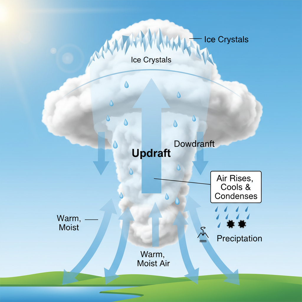 ⚠️ This picture may have spelling mistakes. Trust the words in the lesson.
Keep learning, free
Create a free Syllabax account to unlock practice questions and games for this topic.
Visual Learning Enhanced! 🚀
To help you master this topic, we use Advanced Syllabax AI to generate detailed diagrams and visual models.
Note on Visuals: The AI sometimes makes spelling errors in image labels. Please refer to the lesson text for the correct terminology.